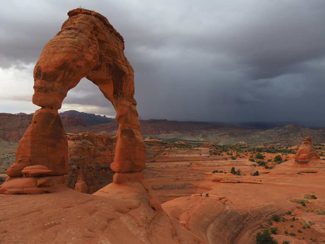
 Delicate Arch, with a storm in the distance.
 Let's be honest. The western United States has some of the most incredible natural features the world has to offer. The Rockies, the Sierras, the Cascades, the Mojave desert, the Pacific coast, the world's tallest, largest and oldest trees, hundreds of glaciers, and so much more.
On our 6 month road trip to 33 western national parks, we wanted to see as much of this as possible, and knew that the only way to really experience all this natural beauty was to get out of the car and go find it. So we hiked 634 miles on more than 100 different hikes. And after all this, we've come to know what makes for a great trail and an even better destination. Here's out list of the best hikes the West has to offer. If you're going to these parks, you simply must put these trails on your agenda!
10. Delicate Arch - Arches National Park
When the trail to Delicate Arch was built, the designers truly had the hiker's experience in mind. There could be a more direct route to hike right up this tall, elegant arch, but instead this 3-mile round trip trail leads you up and around the back of the bowl at the base of the arch. In so doing, you ascend up a steep but manageable cliff face, with the trail blasted right out of the solid rock, and only right at the end do you rise up over a ledge and get rewarded with the spectacular view of the arch from across the bowl.
From here, most hiker's walk to get a closer view or you can also explore the bowl a bit if its steep sides aren't a deterrent. To get the best lighting, this hike is best done at sunrise or sunset, but there will likely be fewer crowds in the early morning. A fit hiker can do the whole hike in an hour or so, plus time spent enjoying the arch itself. Read more on our review of the park.
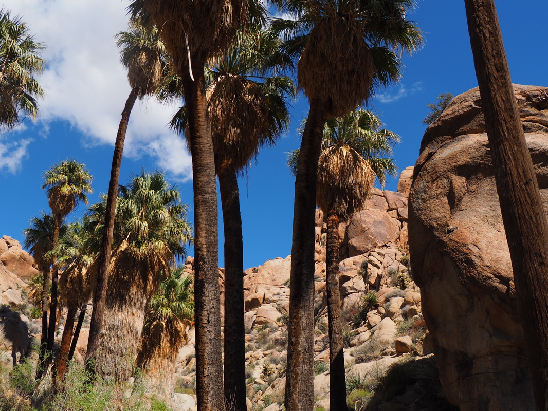 Just a few of the palms at Lost Palms Oasis.
 9. Lost Palms Oasis - Joshua Tree National Park
When wandering through this surreal desert landscape, full of mansion-sized boulders, myriad species of cacti, and plentiful reptiles, you'll not feel likely to happen upon a desert oasis. But hike the trail to Lost Palms Oasis, and that's exactly what you'll be heading towards. At just over 7 miles round trip, this is a fairly easy distance, but when hot (as it often is here) it can be grueling. Fortunately, the destination is a valley oasis of palm trees and fresh water springs, where the temperature is noticeably cooler and the shade is abundant. The final descent into the canyon can be a bit tricky, with a rock scramble here or there, but its not too very difficult and feeling the cool air of the oasis is oh-so-worth-it! Read more on our review of the park.
When wandering through this surreal desert landscape, full of mansion-sized boulders, myriad species of cacti, and plentiful reptiles, you'll not feel likely to happen upon a desert oasis. But hike the trail to Lost Palms Oasis, and that's exactly what you'll be heading towards. At just over 7 miles round trip, this is a fairly easy distance, but when hot (as it often is here) it can be grueling. Fortunately, the destination is a valley oasis of palm trees and fresh water springs, where the temperature is noticeably cooler and the shade is abundant. The final descent into the canyon can be a bit tricky, with a rock scramble here or there, but its not too very difficult and feeling the cool air of the oasis is oh-so-worth-it! Read more on our review of the park.
 Mt. Rainier as seen before the first burrough.
 8. The Burroughs - Mount Rainier National Park
There is something so incredibly powerful about Mount Rainier. Perhaps it's that this mountain has its own weather system. Or maybe it's the combination of wildflowers, glaciers, and views. It's hard to describe to those who haven't had the pleasure of experience it. But once you have the fortune to go to Mount Rainier National Park, to really get the feel of the mountain, you have to get close to it. Short of actual mountaineering, the Burroughs loop trail is one of the best ways to get close.
This moderate to strenuous hike rises up three hills, or burroughs, with increasingly better views of the mountain. At the top of the second burrough, the trail officially ends, but there is a well-established trail going on to the third, and when we hiked it, there were lots of other people continuing on too. From the very top of the third burrough, you have an unobstructed view of 7,000 feet of elevation gain up the mountain. You can hear glacier calving and.or avalanches in the distance, and then spend minutes trying to find the source of the sound as the snow and ice cascade down the side of the massive mountain. This is a magnificent hike, with superlative views of the mountain and several of its gargantuan glaciers. Do it early, as the crowds within a mile or so of the trail head pick up around 10am. Here's our review of the park.
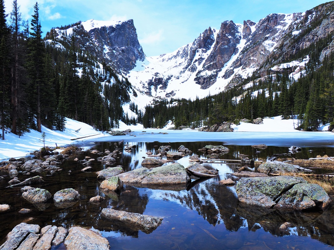 Dream Lake is dreamy indeed.
 7. Nymph Lake - Rocky Mountain National Park
We did the hike to Nymph Lake in May, while there was still feet of snow on the ground, but even then on a weekday morning, it was a very popular hike. While you won't find solitude, you will find postcard-perfect Emerald, Dream, and Nymph Lakes. Hiking up to and around each of these is like finding a little, waterborne gem in the mountains. The hike goes up and up, but it's only a few miles and it's so worth the climb. Be sure to check in with the visitor center, because the trail can be impassable to hikers until enough snow clears. Read more on our review of the park.
We did the hike to Nymph Lake in May, while there was still feet of snow on the ground, but even then on a weekday morning, it was a very popular hike. While you won't find solitude, you will find postcard-perfect Emerald, Dream, and Nymph Lakes. Hiking up to and around each of these is like finding a little, waterborne gem in the mountains. The hike goes up and up, but it's only a few miles and it's so worth the climb. Be sure to check in with the visitor center, because the trail can be impassable to hikers until enough snow clears. Read more on our review of the park.
 The Highline Trail is cut into the Garden Wall, as seen on the right here.
 6. The Highline - Glacier National Park
Hiking along the Highline trail is like taking a geologic tour through time. You can see the shape of the valleys and feel the power of the glaciers that once carved them out of the Earth. This open, exposed hike goes on for more than 20 miles, but the best views are in the first three miles if you start from Logan's Pass. You'll look down on the Going to the Sun Road, and across the valley at crazy mountains and hanging valleys that can only be explained by wacky geology. In the summer, you'll get great views of fields of beautiful wildflowers and there's also a good chance you'll meet a mountain goat or three.
This trail was cut right into the side of the Garden Wall, and it remarkably is relatively level, at least for the first several miles. It does descend a bit, but not much considering the topography we're talking about here, while still offering the incredible views noted above. Once again, this is a popular hike and the Logan's Pass parking area is extremely popular, so its best to take the free park shuttle and start early. Read more on our review of the park.
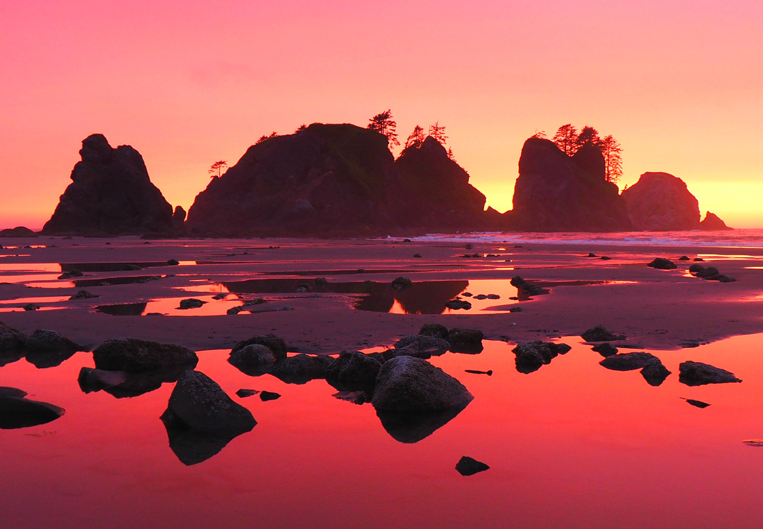 The amazing colors of Shi Shi at sunset.
 5. Shi Shi Beach - Olympic National Park
Tucked way up in the far northwestern tip of the country, Shi Shi Beach is not easy to get to. Even once you're already in Olympic, it still takes hours of driving to get to the trail head and then a mile hike down to the beach, from where you can hike for miles on wide open sandy awesomeness. You can also get there via hiking 20 miles up the rugged Olympic coast from the South. Either way, it's worth every minute. From the far end of Shi Shi, you can explore Point of the Arches, a wild patch of sea stacks and tide pools that does not at all seem earthly (carry a tide table if you do!).
And you absolutely must plan to be there (specifically at the far end of the beach from the trail head) for sunset, when the sun actually sets between two sea stacks, while casting brilliant colors on the tide pools in the foreground (the photo at right is not color-enhanced; this is actually what Shi Shi looks like at sunset). Backpacking in is fun too, because you can camp right on the expansive beach, lighting driftwood campfires at night, while having much of it to yourself, as most visitors come just for the day. Read more on our review of the park.
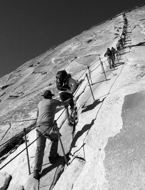 The cable ascent to the top of Half Dome.
 4. Half Dome - Yosemite National Park
Half Dome is not only one of the best hikes in the western U.S., it's one of the best in the world. Unless you're an accomplished rock climber, hiking half dome is the only way to the top of what is perhaps the world's most recognizable topographic feature.
This hike is a beast though, with two routes from the floor of Yosemite Valley clocking in at either 14 or 16 miles and 4,800 feet of elevation gained. You'll switchback up the sides of mountains again and again, past beautiful waterfalls and into Little Yosemite Valley, with the backside of Half Dome visible much of the way. From here, you still have more than half of the climbing to go, and miles more before you even reach the base of the sub-dome. But don't stop now... it's just getting fun. Keep climbing, and pretty soon you'll reach the base of the cable ascent (seen at right), where cables have been installed to make the final push possible. Hauling yourself up these cables is not for the faint of heart of the weak of arm... it's incredibly steep and arm strength is necessary.
But 20 or 30 minutes later, you'll find yourself looking down Yosemite Valley thousands of feet below. You can peer over the sheer face of the cliff if you have the cajones to get close enough. This is an epic place to get some photos in 360 degrees of Yosemite, so don't forget your camera. As with many of the hikes on this list, it's advisable to start early, both to beat the crowds as usual, but also in this case because the hike takes 10-12 hours on average. Read more on our review of the park.
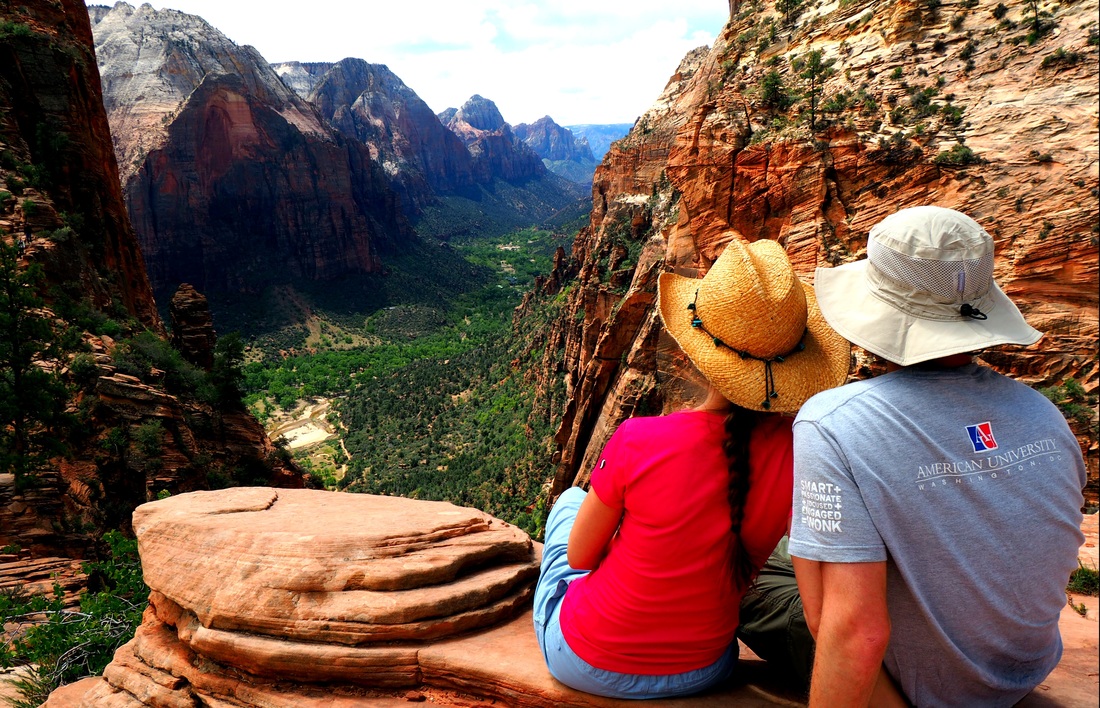 The view from Scout's Lookout.
 3. Angel's Landing - Zion National Park
Without a doubt one of the best designed trails in the National Park System, the hike to Angel's Landing is not to be missed. And while the final ascent to Angel's Landing itself might be a bit too hair-raising for some, the view from Scout's Lookout (just before the top), is also spectacular. With just under 1500 feet of elevation gained, including up the fanciful Walter's Wiggles switchbacks, this 5 mile roundtrip is a fairly easy day-hike. Easy, that is, right up to the point before Scout's Lookout, where cables become necessary to climb up the sandstone rock faces. It's only for a hundred yards or so though, and then you've made it to the Lookout, with outstanding views up and down Zion Canyon.
From here, those with an iron constitution and no fear of heights can proceed on up to Angel's Landing itself, a crowded ascent along an extremely narrow ridge, where cables are once again critical to hauling yourself onwards and upwards. It's a rewarding experience to an iconic destination, but if you're not up for the final push, it's still well worth the hike to Scout's Lookout. Read more on our review of Zion National Park.
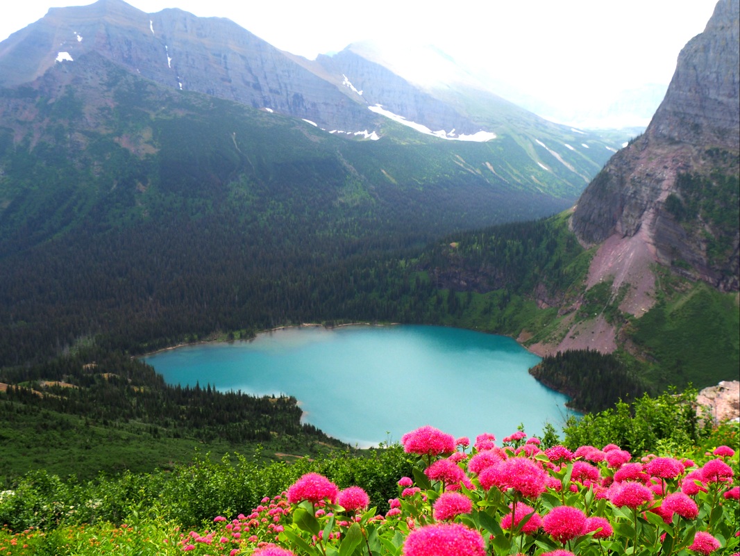 Grinnell Lake and wildflowers.
 2. Grinnell Glacier - Glacier National Park
The fact that this hike's destination, Grinnell Glacier, is projected to be a relic of a warming world by 2020 only adds to its allure. But even without the glacier at the end, this will be a great hike. The trail climbs about 1800 feet as it cuts its way up a ridgeline, with spectacular views of alpine lakes, meadows, and hanging valleys below. And finally, after hiking the first ~5 miles in, you turn a corner, rise above the level of the cirque, and arrive at Grinnell Overloop, with views of Upper Grinnell Lake, Grinnell Glacier behind it, and this side of the Garden Wall.
We strongly recommend you take the time to walk the extra mile roundtrip out to the glacier and back. It's not advisable to walk on it, due to dangerous crevasses, but you can safely go up and touch it. Just don't wait long - Grinnell Glacier is projected to be gone in a few short years. Read more on our review of Glacier National Park.
 The crazy landscape of the Devil's Garden.
 1. Devil's Garden - Arches National Park
The Devil's Garden Primitive Loop hike probably doesn't make many lists of the best hikes in the West. But don't let that stop you - this is an incredibly fun, interactive, and challenging hike. It's also a great way to see a lot of Arches' arches at once. Plus it's not that crowded on the Primitive Loop, which is a welcome difference from many of the other (very popular) trails on this list. You'll start off on an easy gravel path until you get to Landscape Arch (longest natural arch in the world).
It's here that the Primitive Loop breaks off and leads you on a fun-filled jaunt to several other arches, including Ryan's personal favorite, Navajo Arch. And in between these, you'll have a great time navigating the 7.2 mile trail via frequent cairns, following it up and down sandstone rock faces, around, between or above massive fins, and more. We love this hike and we hope you do too! Pro Tip: do the Primitive Loop counter-clockwise. Read more on our review of Arches National Park.
Got ideas for hikes we've missed or disagree about the ones we liked? Let us know in the comments!

 RSS Feed
